


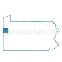
SALEM TWP Voting District, Mercer County, Pennsylvania
About
Outline

Summary
| Unique Area Identifier | 661152 |
| Name | SALEM TWP Voting District |
| County | Mercer County |
| State | Pennsylvania |
| Area (square miles) | 13.39 |
| Land Area (square miles) | 13.36 |
| Water Area (square miles) | 0.03 |
| % of Land Area | 99.80 |
| % of Water Area | 0.20 |
| Latitude of the Internal Point | 41.45381520 |
| Longtitude of the Internal Point | -80.29948660 |
Maps


Graphs
Select a template below for downloading or customizing gragh for SALEM TWP Voting District, Mercer County, Pennsylvania


Neighbors
Neighoring Voting District (by Name) Neighboring Voting District on the Map
- EAST FALLOWFIELD TWP Voting District, Crawford County, PA
- GREENWOOD TWP Voting District, Crawford County, PA
- OTTER CREEK TWP Voting District, Mercer County, PA
- PERRY TWP Voting District, Mercer County, PA
- SANDY CREEK TWP Voting District, Mercer County, PA
- SUGAR GROVE TWP Voting District, Mercer County, PA
Top 10 Neighboring County Subdivision (by Population) Neighboring County Subdivision on the Map
- East Fallowfield township, Crawford County, PA (1,620)
- Greenwood township, Crawford County, PA (1,454)
- Perry township, Mercer County, PA (1,453)
- Sugar Grove township, Mercer County, PA (971)
- Sandy Creek township, Mercer County, PA (795)
- Salem township, Mercer County, PA (754)
- Otter Creek township, Mercer County, PA (589)
Top 10 Neighboring Unified School District (by Population) Neighboring Unified School District on the Map
- Conneaut School District, PA (18,617)
- Greenville Area School District, PA (10,634)
- Commodore Perry School District, PA (4,235)
Top 10 Neighboring State Legislative District Lower Chamber (by Population) Neighboring State Legislative District Lower Chamber on the Map
Top 10 Neighboring State Legislative District Upper Chamber (by Population) Neighboring State Legislative District Upper Chamber on the Map
Top 10 Neighboring 111th Congressional District (by Population) Neighboring 111th Congressional District on the Map
Top 10 Neighboring Census Tract (by Population) Neighboring Census Tract on the Map
- Census Tract 318, Mercer County, PA (5,006)
- Census Tract 319, Mercer County, PA (4,712)
- Census Tract 1119, Crawford County, PA (3,679)